| Little Crosby and Thornton |  |
|||
| Little Crosby and Thornton |  |
|||
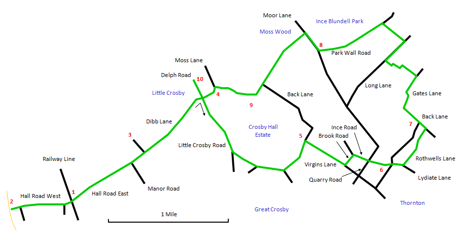
This is a pleasant walk of 7½ miles (12 km) on level ground along suburban roads, country lanes and rural paths. It starts and finishes at Hall Road station. If you like you can do just the circular part of the route at 4½ miles (7½ km). It starts with a short stretch down to the coast and then returns through a smart suburban area and out into the countryside. Little Crosby is a tiny unspoilt village that is very attractive. At Thornton, you enter the suburbs again for a short stretch and then into open farmland and woods, passing a few ancient relics along the way. I didn't meet another soul on this part of the route when I did it last. The Courtyard in Little Crosby is a nice place to stop for refreshments and the route passes two pubs in Thornton: the Grapes and the Nag's Head. A few of the paths can be very muddy after rain, so take appropriate care with footwear. |
 |
Turn right out of Hall Road station [1] and walk down to the end of Hall Road West to the coastguard station [2] and the waterfront promenade. Antony Gormley's shoreline installation Another Place can be seen from here and there is often a fine view of the North Wales Coast. Once you have aired your lungs, retrace your steps to the station and continue along Hall Road East. |
The road takes a turn to the right at Manor Road, but keep on straight ahead along the broad path through the fields known as Dibb Lane. On your left is the oddly named Sniggery Wood [3] and ahead is a distant view of Little Crosby with St. Mary's Church spire [4] prominent. |
Dibb Lane exits into Little Crosby village. Turn right at Little Crosby Road and note the many early 17th century cottages and the wayside cross. There is also a museum, which I have not yet managed to find open. At the end of the village, go through a gate on the left onto a path that follows the wall of Crosby Hall estate. Keep alongside the wall past two footpaths to the right: one signposted Great Crosby and one Chestnut Avenue. |
The path comes out through a gate by a lodge house [5] onto Virgins Lane. Turn right here and follow the road. Then turn left onto Brook Road and right onto Ince Road. Cross carefully over busy Quarry Road onto Lydiate Lane. |
You pass the Grapes pub and then opposite the Nag's Head are Thornton's old stocks and sundial [6]. A little further on, turn left along Rothwells Lane. Keep straight ahead as the road becomes a narrow path. You are soon on Back Lane where the way is to the left. |
Along Back Lane you pass the pedestal of Brooms Cross [7]. There is an expansive view here to the north-east towards Aughton. The path bends to the right and becomes Gates Lane. Look out for a yellow waymarker arrow pointing left and follow this route as it doglegs across the fields to emerge on Long Lane. Turn right and watch out for a footpath on the left through a line of trees. This path can be very muddy! It crosses Hunt's Brook to emerge on Park Wall Road. Turn left here following the road alongside the wall of Ince Blundell Park. |
Park Wall Road comes out on the very busy Moor Lane by the Lion Gates [8] to Ince Blundell Hall. Cross with care and follow the main road to the right. Shortly after Sunnyfield Farm a footpath goes off on the left, signposted Back Lane, along the edge of Moss Wood (known universally locally as Ince Woods). Pheasants are likely to fly out suddenly at you here. When the path emerges on Back Lane, follow the road straight ahead, where you will see some of the buildings of Crosby Hall [9]. Further on you reach St. Mary's church and a school on the opposite side of the road (there used to be a road sign near here saying Danger, children round the bend). At the start of Dibb Lane you can if you choose turn right along Delph Road to visit The Courtyard [10], a good place for food and refreshments. Retrace your steps along Dibb Lane (along which I had the company of a very vocal skylark) and Hall Road East to the station. |