Ainsdale Nature Reserve
allertonOak  
Last updated 30th January 2007
 Home Page: merseyWalks       Home Page: allertonOak      

This walk around Ainsdale National Nature Reserve and the adjoining countryside is about 6 miles (9½ km) in length. There is a nice variety of terrain: pinewoods, dunes, wetlands, scrub and seashore. The stretch along the shore is exhilarating, especially with the waves alongside, but it is impassable near to high tide, so you will have to check the tide timetable. If necessary you can always move into the dunes, where there are several trails. A good deal is over sand or sandy trails and the wetlands can be just that: wet. The rest is on firm, though sometimes muddy, tracks. Adorn your feet accordingly. This is a circular route and it is possible to join it from the beach car park at Ainsdale (a short walk along the shore) or from Freshfield Station (along the eastern side the railway track and then over an unsupervised crossing and the golf course - under a mile or 1½ km).

The relevant Ordnance Survey 1:25000 Explorer map is No. 285. For further information on the locations visited, click on the images.

Detailed mapping and satellite photography for this walk courtesy of Bing Maps
Printer friendly page for this walk (no photos)
CLICK ON THE IMAGES FOR MORE INFORMATION

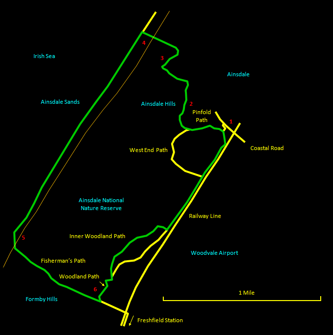
Start at the reserve entrance [1] down the lane on the left just over the railway bridge on the Coastal Road opposite a point marked on the map, somewhat enigmatically, as Big Balls Hill. There is no public parking here, but you can leave your car on one of the suburban roads on the other side of the bridge. Shortly after the entrance gate, take the Pinfold Path to the right and follow the green markers. This winds through pine woods, then through dunes and finally over more open grassland. Eventually it leaves the reserve [2] and the way markers become white. It winds around quite a lot through the dune hinterland. At a sign indicating that the path is heading for the shore road, turn left up a dune from where you can see the sea. Head along less distinct tracks towards the sea until you see the white markers again. Follow the markers to the right to emerge into an area of wetland [3].

Skirt round the water to the right (it may be drier in summer) and on the far side strike out over the dunes [4] to the seashore. The initial view of the coastal dune strip is surprising - like waves of sand. Looking right along the shore you may be able to see Blackpool tower directly behind the big dipper. Now turn left along the shore for the brisk stroll down to Freshfield. Halfway along, where the dunes have gradually risen higher, a barrier across the beach marks your re-rentry to the reserve.

You will soon see Formby Point appear beyond the nearer headland. Look out for a yellow marker post [5] marked 'Fisherman's Path' near where the dunes reach their highest point and there is the first big gap. Route finding is a bit tricky here. Leave the marker post following the sandy depression at about 45° to the shore heading south. After a few yards you should be able to see a red topped marker post in the distance at the edge of the sand in front of some pinewoods. Walk up to the post and go straight past it down a short, steep, sandy slope. At the bottom is a green information board. The Fisherman's Path heads off into the woods in front of you marked with red topped posts.

Follow the Fisherman's Path through the woods. Near the far edge of the woods, turn left at a gate [6] near some information boards onto the Woodland Path. After a little while look out for the Inner Woodland Path going off on the left. Follow this as it twists and turns and finally returns to the Woodland Path. Go left here alongside the railway track to return to the start.