| Formby and Freshfield |
|
|||||||
| Formby and Freshfield |
|
|||||||
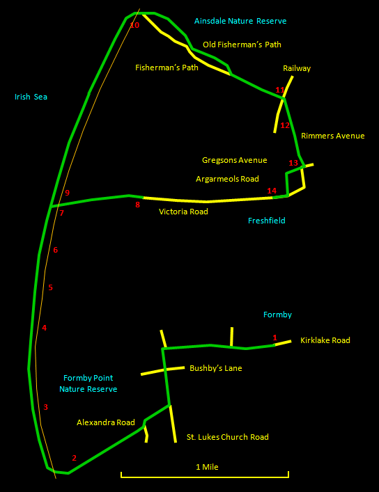
This walk from Formby to Freshfield along the coast is about 6 miles (9½ km) in length or 7 miles (11½ km) if you take the diversion to see the Red Squirrel Sanctuary. The 3 mile (5 km) stretch along the shore either side of Formby Point can only be described as exhilarating and it is worth trying to schedule the walk near high tide as the presence of the sea makes all the difference. Near the end, the section along the Old Fisherman's Path is a complete contrast, passing through some particularly attractive dunes, woodland and scrub. The route is not circular, but uses the frequent trains back to Formby from Freshfield. The walk can be split in two by using Victoria Road to get to or from Freshfield railway station; the northern (circular) route is 3½ miles (5½ km) and the southern (non-circular) is 4 miles (6½ km). The way is on suburban roads, good tracks, firm sand and short sections of dunes; any sensible shoes will be fine. The relevant Ordnance Survey 1:25000 Explorer map is No. 285. For further information on the locations visited, click on the images. |
 |
| CLICK ON THE IMAGES FOR MORE INFORMATION |
Between the old lifeboat station and the marker post for Blundell Avenue [5] is Formby Point [4], the westernmost part of the Sefton coast, with huge dunes all along. Here, the distant horizon to the north opens up, with Blackpool Tower and roller coaster visible and, further west, the mountains of the Lake District ending in the isolated hump of Black Combe. Past the Blundell Avenue marker, there are blackened stumps of what look like ancient trees on the beach. Near here is the waymarker for the Nicotine Trail, not a special smokers zone but where the tipping of tobacco processing waste, once a major industry in Liverpool, used to take place. |
Shortly you reach the waymarker for Victoria Road [7]. The Red Squirrel Sanctuary [8] is about half a mile (1 km) inland along here if you want to make the diversion to see the cute little furry things (not in winter though - hibernation). This route continues to Freshfield station if you are doing one of the shorter walks. Past the Victoria Road waymarker is an area of scattered eroded housing rubble [9]. This is where some old fishermen's cottages were washed into the sea, a reminder of the dynamic nature of the coastline here. |