Hunt's Cross to West Derby
allertonOak  
Last updated 5th April 2007
 Home Page: merseyWalks       Home Page: allertonOak      

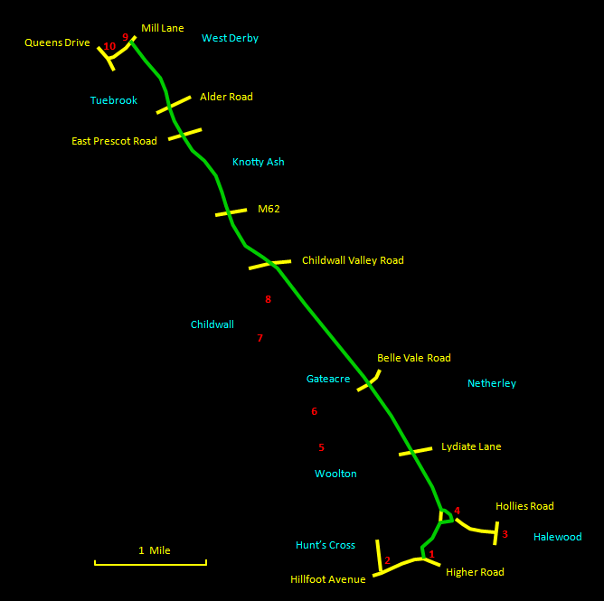
This is a walk of about 6½ miles (10½ km) along the Liverpool Loop Line, the route of the dismantled Cheshire Lines railway and part of the Transpennine Trail. It does not have a huge degree of scenic interest, but is a remarkably pleasant route. Although it passes through suburban areas, there is a feeling of isolation and peacefulness most of the time. This is created by an abundance of trees and frequent adjacent green areas. Halewood Triangle Country Park at the start is particularly attractive. Further on the route is embanked, with views to both sides, while the final stages consist of an atmospheric cutting in the sandstone. Railway buffs will relish the few remains of old stations. This is another very straightforward route, to be enjoyed at a brisk pace, or it can equally well be cycled. The surfaces are all firm, so use any fairly sturdy shoes. The suggested start is best if you want to use a return bus back to Hunt's Cross, but you can also start at Halewood Station or the Halewood Triangle Visitor Centre.

The relevant Ordnance Survey 1:25000 Explorer map is No. 275. For further information on the locations visited, click on the images.

Detailed mapping and satellite photography for this walk courtesy of Bing Maps
Printer friendly page for this walk (no photos)
CLICK ON THE IMAGES FOR MORE INFORMATION

Start at the entrance to Halewood Triangle Country Park on Higher Road [1] next to a children's nursery and a short walk from Hunt's Cross station [2]. Other possible starts are Halewood station [3] or the visitor centre [4]. Cross the bridge over the railway and keep ahead along the broad path down the hill and through the trees. Turn right at the sign for the visitor centre. Have a look in the visitor centre [4] if you wish, but our route goes left just before you leave the park along a boardwalk. This eventually rejoins the main path following the old railway line. Past Lydiate Lane, the view opens up to Prescot and the surrounding region on the right, and Woolton, with St. Peter's Church [5] prominent, on the left. Further on, the left-hand skyline is the wooded area incorporating Reynolds Park [6]. Passing Gateacre, the skyline on the left is dominated by Childwall Woods [7], and then there is a lovely view over towards Childwall Village with All Saints Church [8] and the Childwall Abbey nestling in the trees.

Next you pass under the M62 and the adjacent road and railway. At East Prescot Road, you skirt around a supermarket and on the other side of a tunnel are the remains of the platform of the former Knotty Ash station. Here the route becomes a cutting with brooding sandstone walls and several old bridges.

Finally you approach West Derby station [9] through another tunnel. This station is by far the best preserved, with the station buildings intact though in alternative use. Exit the route up the ramp to the left of the station buildings to Mill Lane. Turn left onto Mill Lane and walk along to Queens Drive. Turn right here for the 81A bus back to Hunt's Cross, which stops outside Holly Lodge school [10].