Runcorn Hill
allertonOak  
Last updated 29th May 2006
 Home Page: merseyWalks       Home Page: allertonOak      

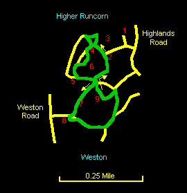
This is a only short circuit of about a mile (1½ km) around Runcorn Hill Nature Reserve but it is nevertheless of exceptional interest. Wide vistas over the Mersey Estuary are combined with the vertiginous cliffs of the old Runcorn Hill Quarry. Runcorn is a closed book to most non-Runcorners, seemingly cut off as it is by the encircling expressways. It was so to me until recently when I went exploring after a close look at the map. I was expecting a good view of the river but was hardly prepared for the drama of the location. The route described is somewhat rough in places and stout shoes, at least, are recommended.

The relevant Ordnance Survey 1:25000 Explorer map is No. 275. For further information on the locations visited, click on the images.

Detailed mapping and satellite photography for this walk courtesy of Bing Maps
Printer friendly page for this walk (no photos)
CLICK ON THE IMAGES FOR MORE INFORMATION

Start in the car park [2] at the end of the track off Highlands Road by the Travellers' Rest pub [1]. Follow the signs along the path to the cliffs with a reservoir [3] on the right. At the cliff top the views over the Mersey Estuary are tremendous and include Liverpool Anglican cathedral, Hale lighthouse, the Clwydian Hills and the Frodsham and Helsby Hills. The sandstone cliffs fall away vertically in breathtaking drops with overhangs at the top. Wander around with care admiring the rock structures.


Follow the path to the north that descends to the base of the cliffs. Go left at the bottom and then, where the cliffs come into view from below, to take the path to the left again down steps to the base of the cliffs [4]. The view of the vertical rock faces from below is very impressive. Follow the ups and downs of the path at the bottom of the cliffs until it emerges into a dell surrounded by rock faces. Go ahead as far as you can until you reach a rock wall with a carving of a lizard on it [5]. Go left up the steps along the rock face and through a gully that emerges back on top of the hill with another reservoir [6] on the left.

Go sharp right at the top of the hill following a path that passes just to the right of a pylon [7]. Just past here, descend steps to a footbridge that crosses a path coming up from Weston Road. At the top of the hill on the right is a bench [8] where you can stop to take in the view again. Follow the steps down and then turn right onto the path coming up under the bridge. This follows a pleasant valley through silver birches for a while. Keep to the main track as it gradually curves to the north, ignoring several tracks off on the right.

Soon after sandstone outcrops start to appear again up on the left, there is a meeting of several ways by a tree stump and a carved stone pillar. Take the rather steep and rough path sharp left up the hillside. Go right at the top towards a viewfinder table [9]. The path then eventually descends in steps and bears round to the right with the reservoir [6] ahead that you passed earlier. Go right alongside the reservoir and then left to return to the car park [2].