Seacombe to New Brighton
allertonOak  
Last updated 5th March 2013
 Home Page: merseyWalks       Home Page: allertonOak      

Tagged on to the ferry crossing from Liverpool, this could be the most popular walk of all for Liverpudlians. From Seacombe landing stage, it is about 3½ miles (5½ km) in length and its popularity derives from the superb river views, the bracing air and the charm of the riverside area. In former times, New Brighton was a big attraction, on a par with Blackpool. Nowadays it is somewhat faded as a resort, though undergoing a revival, and worth a visit because its location at the northern tip of the Wirral is as fine as ever. In the peaceful old part of New Brighton the characterful Magazine pub is a good place to stop for refreshments, or, at the end of the walk, the new Floral Pavilion or one of the fish and chip shops. The way is all on hard surfaces, so wear comfortable shoes. It is also suitable for cyclists. The route is linear, but many people retrace their steps to Seacombe. Alternatively, frequent trains leave the station at New Brighton for Liverpool and the rest of Wirral.

The relevant Ordnance Survey 1:25000 Explorer map is No. 266. For further information on the locations visited, click on the images.

Detailed mapping and satellite photography for this walk courtesy of Bing Maps
Printer friendly page for this walk (no photos)
CLICK ON THE IMAGES FOR MORE INFORMATION

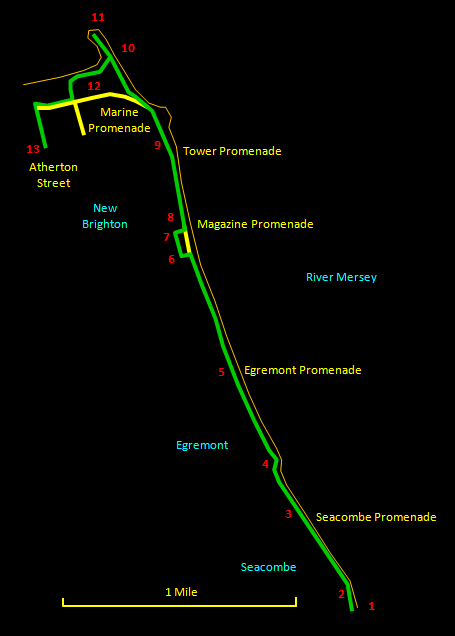
Set off north from the Seacombe landing stage [1] past the vast ventilation tower [2] for the Wallasey road tunnel. There is a fine view back to the Liverpool waterfront. Soon you pass the rather grand Wallasey Town Hall [3].

A little further on, jutting out into the river, is the old Egremont Ferry quay [4], where there is a Speakers' Corner. This is a pleasant place to sit and take in the view across the river or north along Egremont Promenade.

A pleasant stretch now along Egremont Promenade with its elegant houses passes the memorial to Mother Redcap's [5], a famous sailors' pub in olden times but now long gone. Look out for a little road, Pengwern Terrace, going up the hill away from the river. At the top of this is the Magazine pub [6], where you can sit outside and look over the river.


Go right at the pub along Magazine Brow, which passes through a small and peaceful old corner of New Brighton with charming cottages. A little further along are the castellated remains of the Magazine itself [7], which used to be used for the storage of gunpowder. Turn right here to Vale Park [8] and cut across it to return to the river. Past Vale Park is a grassy area on the left known as Tower Grounds [9]. This is where the Tower Ballroom and New Brighton Tower itself used to be, with the pier just opposite. The tower was completed in 1900, 10 years after Blackpool Tower and, at 567 ft (173 m), was 49 ft (15 m) taller. It was modelled on the Eiffel Tower and completed in 1900. It had been dismantled by 1921 because lack of maintenance during World War I had caused the structure to become unsafe.

You are now approaching the end of the Mersey estuary and you will see Fort Perch Rock [10] ahead. Behind this, on the extreme northern tip of the Wirral, is New Brighton Lighthouse [11], which you can walk out to at low tide. There is a fine, clean, sandy beach here and it is a great spot to take in the bracing sea air and views. Return around the seaward side of the Marine Lake [12] and turn right along the Marine Promenade then left up Atherton Street to reach New Brighton station [13].